![]()
![]() I first heard about Geocaching
in September 2000 on Slashdot.
I first heard about Geocaching
in September 2000 on Slashdot.
It's the perfect outdoor sport for computer geeks like me.
What is it?
The Geocaching FAQ covers most questions, but to put it simply:
Take a container and hide it somewhere in the world, record the latitude and longitude using your GPS receiver, and post the location to the Geocaching website so that others can find your stash. Finding the stash is it's own reward, but most caches contain some sort of trade-able item. Sign the logbook, take something, leave something.
I've only been caching since May 2002. It took me that long (nearly a year-and-a-half) to get into Geocaching, because I simply didn't have a GPS receiver!
My Cache Stats as of 5/9/2007 (Get your own CacheStats at www.logicweave.com)
| Cache Finds | |||
| Total Found: | 300 (# found/attended logs) | Find Rate: | 0.166 per day (1.2 per week, 60 per year) |
| Caches: | 300 (# unique caches visited) | Avg. difficulty / terrain: | 1.84 / 1.61 |
| # Archived: | 111 (37%) | FTFs: | 7 |
| Avg. in 1 day: | 2.2 | Oldest Cache: | Singletrack Stash (GC183 placed 1/17/2001) |
| Most in 1 day: | 18 | Most in 1 month: | 24 |
| Days Cached | |||
| Total days cached: | 134 (every 13.4 days or 7.4%) | Most consecutive days with a find: | 3 |
| Most in 1 month: | 13 | Most consecutive days without a find: | 293 |
| History | |||
| Year | Total Found | Rate | Days Cached / Frequency |
| 2002 | 80 | 0.374 | 48 / every 4.5 days |
| 2003 | 78 | 0.214 | 45 / every 8.1 days |
| 2004 | 59 | 0.162 | 14 / every 26.1 days |
| 2005 | 30 | 0.082 | 11 / every 33.2 days |
| 2006 | 48 | 0.132 | 13 / every 28.1 days |
| 2007 | 5 | 0.039 | 3 / every 43.0 days |
| Milestones | |||
| Number | Date | Cache | # Days between |
| #1 | 6/1/2002 | Far Horizons | |
| #100 | 3/16/2003 | Tsunami's Doggie Cache for Dog lovers! | 288 |
| #200 | 5/8/2004 | A Pause To Refresh | 419 |
| #300 | 4/28/2007 | Creek Bed | 1085 |
| Favorite and other Notable Caches | |||
| Category | Cache | Log | Comment |
| All-time favorite | Gorillas Gatorade | View | |
| Recent favorite | Missile-Tow | View | |
| Most memorable | Tangled Up In Belews | View | |
| Favorite Multi | Three Hour Tour | View | |
| Most difficult find | Daniel Boone's Secret Stash | View | |
| Most difficult terrain | Slippery When Wet | View | |
| Most scenic | John's Rock Cache | View | |
| Best hike | RLDILL 2 "WATER EVERY WHERE WATER?" but the maps | View | |
| Cleverest hide | A Point In The Distance | View | |
| FTFs | |||
| Number | Date | Cache | Log |
| 1 | 6/3/2002 | Austin's "Why Can't We Dig It Up Now?" Cache | View |
| 2 | 7/16/2002 | Hampton's Quest | View |
| 3 | 7/29/2002 | Between a Rock and a Low Place | View |
| 4 | 9/4/2002 | King's Ransom | View |
| 5 | 10/3/2002 | The Great "Stamp"ede Stash - postage due! | View |
| 6 | 2/2/2003 | GEO ~ HOGGIN' | View |
| 7 | 9/8/2003 | Best of Luck | View |
| Locations | |
| US States (7): | NC, IL, CA, NY, VA, SC, FL |
| Countries (1): | United States |
Update Sep 26 2005 - Profile
I need to update this site, but until then, I'm cleaning up the 'Caches Found' clutter below.

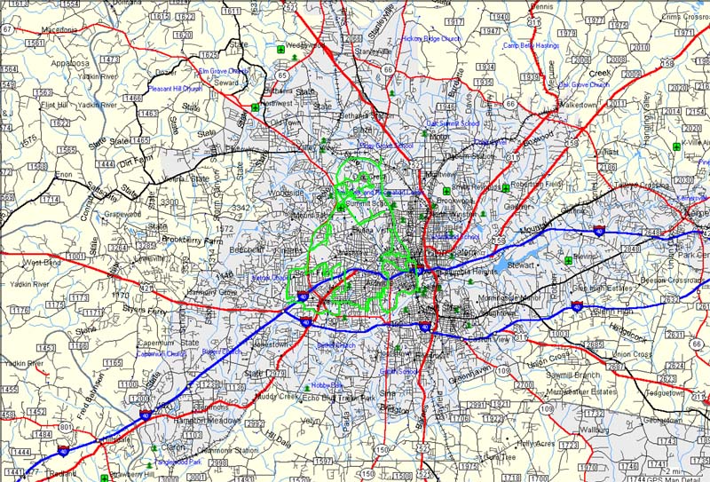
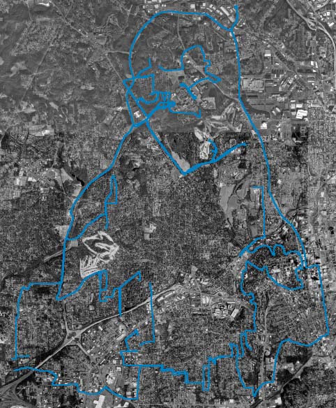
Update Dec 21, 2003 - GPS Drawing - I like the idea behind GPS Drawing, so I decided to give it a shot.
Here's my first experiment; I tried to create an image of Tux the Penguin, the Linux mascot, while
driving around Winston-Salem NC. Unfortunately, the roads didn't always cooperate, so
here's my best effort.
Total distance: 52.77 miles
Total Time: 02h 38m


Quick Links to Sections Below:
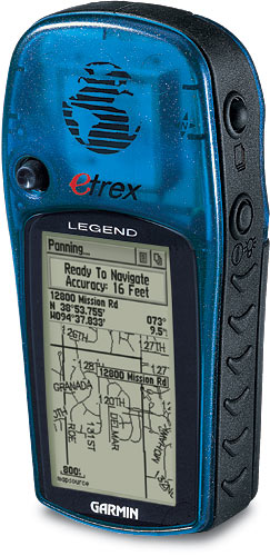
When my mother and I first started Geocaching, we used a Garmin GPS 12. Although a very nice unit, it certainly doesn't have the mapping and extended features our Garmin eTrex Legends. There are several models in the eTtrex family of products, ranging from $99 to $350. My sister uses the $99 basic eTrex Yellow.
GPS Software - Looking for software to use with your GPS receiver?
Windows/Win32 - There are many more apps for Windows-based PC's:
EasyGPS - Geocaching.com offers the Groundspeak Version of EasyGPS for waypoint management.
It is a very handy app, especially for caches or groups of caches that you download from the Geocaching website.GPSBabel - GPSBabel is the Swiss army knife of GPS conversion tools! GPSBabel runs on Microsoft Windows 95, 98, ME, 2000, and XP plus POSIX OSes such as Linux, UnixWare, OpenServer, Solaris, FreeBSD, and OSX
USAPhotoMaps - This is by far the most useful GPS app I've found yet. USAPhotoMaps creates scrollable/zoomable aerial photo and topo maps from Microsoft's TerraServer, and displays GPS data including waypoints and track logs.
Garmin MapSource - Garmin's own mapping and navigation software. It provides a PC interface to creating waypoints and routes, and management of track logs. The real-time navigation feature is great for road trips. This software is required to load Garmin's maps onto your Garmin mapping GPSr.
geocaching2gpstrans - JBadger has written this perl script to convert Geocaching .LOC files to a format readable by gpstrans.
geo2WindowsXPbat - This JBadger perl script converts Geocaching .LOC files to Windows XP batch files that print out the cache pages. This requires you to be logged in.
gpx2links - This JBadger perl script converts Geocaching .GPX files to Windows XP batch files that print out the cache pages. This requires you to be logged in.
gpx2tb - This JBadger perl script converts Geocaching .GPX files to a text list of the travel bugs in the caches.
- GPS TrackMaker - Another software package to download and display your track logs.
Linux - I've found a few handy utilities for my Linux-powered laptop:
GPSBabel - GPSBabel is the Swiss army knife of GPS conversion tools! GPSBabel runs on Microsoft Windows 95, 98, ME, 2000, and XP plus POSIX OSes such as Linux, UnixWare, OpenServer, Solaris, FreeBSD, and OSX
GpsDrive - For real-time navigation, it's a great free replacement for MapSource.
gpstrans - Transfers track, route, and waypoint data to and from a Garmin GPS
geocaching2gpstrans - JBadger has written this perl script to convert Geocaching .LOC files to a format readable by gpstrans.
gpx2gpstrans - JBadger has written this perl script to convert Geocaching .GPX files to a format readable by gpstrans.
gpx2gpsman - JBadger has written this perl script to convert Geocaching .GPX files to a format readable by GPS Manager.
GPS Manager - It manages waypoints and tracks, but the mapping interface is at bit tricky. It's a Tcl/Tk application, so you can run on any platform that has a Tcl interpreter, including UNIX, Windows, and Macintosh.
gpspoint - It's a nice command-line-based Linux app that manages waypoints and tracks. It doesn't cover the specialized needs like the previously listed apps, but it always works in a pinch. This one also claims to have a Win32 port, but I could never get it to work.
MapBlast to Route- mb2route is a short PERL script that converts the detailed directions produced by MapBlast.com to a route file that you can upload to your Garmin GPS unit. It tries to use gpstrans to push the route up to your GPS, but will also output to a plaintext file. On or around 27 August 2002, Mapblast.com (actually Vicinity.com) stopped offering lat/long coordinate searches and turn-by-turn directions, because they had a contractual problem with the third party provider of the map data. This has effectively broken mb2route. :(
Palm - As a paying member of Geocaching.com, I'm using Pocket Queries, which are customized cache queries you can have generated on a daily or weekly basis. My queries generate an EasyGPS LOC file and MobiPocket eBook format to bring on the hunt. Other handy Palm-related utilities include:
CacheMate™ - This is Maeglin's new database app for tracking GPS cache hunts. You can store information about caches or benchmarks, decode hints, and transfer data between CacheMate and the MemoPad application. Other features include:
- Sony/HandEra/Palm hi-res support
- Palm OS� 5 compatibility
- Editable cache type list
- Support for the Palm OS� Find system
- Import/export data with MemoPad
- Geocaching hint decoderGeocache Log Book - This is a simple, but handy Palm app to log your finds.
Authored by benjamin921.MobiPocket - E-book reader for Palm (and other handheld platforms).
SunAngle - SunAngle displays data about the Sun's rise time, set time, and its current bearing. By pointing your Palm Pilot at the Sun, this program will tell you which way is North. In addition, it draws pie slices on the compass face showing where the Sun will rise and set that day, during the summer solstice and winter solstice. (Very handy when you forget your compass!)
MobiPocket to PalmDoc Converter - If you don't want to load MobiPocket on your PDA, use this to convert the Mobi eBook to PalmDoc format.
GPX to PalmDoc Converter - Same here, but uses the GPX-format file from your pocket queries.
Other Geocaching Resources
Latest Update: Monday, September 26, 2005;
As of today, I've hidden 6 caches, and found 227 caches within:
| Benchmarks I Have Found | ||
| 1/4/2003 | FZ0079 | |
| 1/4/2003 | FZ0078 | |
| 11/25/2002 | FZ0077 | |
| 11/25/2002 | FZ0297 | |
Need more information? Follow the links above, contact me, or free to browse my profile.


Last modified 05/09/2007 by bart at spainhour dot com
http://www.spainhour.com/geocaching/
![]()